
Explore and learn

The Bulkley Valley is the TRADITIONAL TERRITORY OF THE WITSUWIT'EN, who have lived here for countless generations. Their rich culture is seen and heard throughout the valley, the land that they have known and loved longer than memory can recount.
WITSET
Head 20 minutes west to WITSET (formerly Moricetown) for a CULTURAL TOUR, a MUSEUM VISIT and to witness the SPECTACULAR WITSET CANYON. You can stay at the CAMPGROUND & RV PARK right next to the canyon!
SMITHERS
The story of the TOWN OF SMITHERS begins in 1913 with the coming of the RAILROAD. Learn more about it by checkin in at the BULKLEY VALLEY MUSEUM and take a SELF-GUIDED HISTORICAL WALKING TOUR OF SMITHERS that will lead you through the streets of Smithers to some of our LANDMARKS, including HISTORICAL EXHIBITS in stores, cafés, a public garden and heritage buildings. Pick up your FREE GUIDE MAP at the Smithers VISITOR CENTRE or at the BV MUSEUM – both located by Central Park – and inquire about guided tours. Be sure to ask museum staff about the LOCAL FOSSIL BEDS, B-36 GUN TURRET, INVENTION OF THE EGG CARTON, and the MAIN STREET FIRES! You can also view the Walking Tour Map virtually on GOOGLE EARTH here.
TELKWA
The picturesque, historic VILLAGE OF TELKWA sits on the TRADITIONAL TERRITORY OF THE GITDUMDEN CLAN OF THE WITSUWIT'EN PEOPLE. Indigenous people often came to fish at the junction of the Telkwa and Witzin’kwa (also known as Bulkley) Rivers. In the Witsuwit'en language, “Telkwa” means “muddy river”, referring to its colour in the spring. The syllable “kwa” or “qua” means “river”. It was in 1906 that surveyors first laid out the townsite of Telkwa, although prospectors had been mining in the area for quite a few years. The first townsite in the area, ALDERMERE, was originally established on the bluff above the Bulkley River, located on the Telegraph Trail system, and was a central restocking spot for prospectors following the call of the GOLD RUSH. As the GRAND TRUNK PACIFIC RAILWAY began constructing the western section of their railway in 1907, many businesses and settlers began to move down the hill to the present site of Telkwa to be closer to the anticipated railway and for easier access to water. Discover the history of existing buildings and what you might have seen in Telkwa in the early 20th century by downloading the SELF-GUIDED WALKING TOUR OF TELKWA or pick up a brochure at the VILLAGE OF TELKWA office or TELKWA MUSEUM.

Christine Namox, Madeline Dennis, Connie Tiljoe, Mary George and Madeline Alfred at Smithers, B.C. 25th anniversary celebration. Written on back of photo "Indian women at Smithers Birthday Celebration Aug 1938". Photo by Val Tomlinson, 1913. P3518, Bulkley Valley Museum visual record collection.

Before lots were formally offered for sale, merchants and businesses such as druggist J. Mason Adams and the Union Bank began operating out of tents on the Smithers townsite. Photo by William W. Wrathall, 1913. P2599, Bulkley Valley Museum visual record collection.
Land of the Wet’suwet’en
This land of the Wet’suwet’en stretches from Tweedsmuir Provincial Park in the south to Babine Lake in the north, to Fraser Lake in the east and to Hazelton in the west. Wet’suwet’en people inhabited this area when European settlers first arrived in the late 1800s and they live here still. The largest Wet’suwet’en community today is Witset (Moricetown) on the Widzin Kwah (Bulkley River). The village is situated on the banks of the river where it narrows to a spectacular gorge known as Widzin Kwah Canyon. Migrating salmon stop to rest in the calm waters downstream of the canyon and that abundance of salmon is what makes this an important fishing spot both historically and today.

Widzin Kwah (Moricetown) Canyonphoto: Community Futures 1637
See Widzin Kwah (Moricetown) Canyon
This is a must-see! The rush of the river as it squeezes through the gorge is mesmerizing. It can be heart-stopping to watch the Wet’suwet’en fishers out on the rocks, close to the exploding whitewater, plunging poles into the water to catch powerful salmon in dip nets. The river here can be loaded with salmon (springs or kings, coho, sockeye, pinks) and steelhead swimming upriver to spawning grounds on the Bulkley and Morice Rivers and their tributaries. Watch from above or walk the paths into the canyon. Be careful as you near the river—the rocks are slippery.

Widzin Kwah (Moricetown) Canyon. photo Walter Joseph
Fish at Idiot Rock
If you want to try your hand at fishing in Witset, your best bet is “Idiot Rock” just downstream of the canyon. You will need a valid BC angling licence which you can buy online or at fishing shops in Smithers.
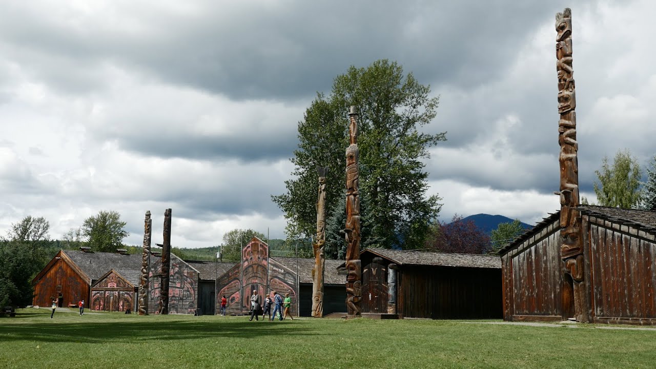
Explore the Widzin Kwah Canyon House Museum
Widzin Kwah Diyik Be Yikh (Widzin Kwah Canyon House Museum) is directly above the canyon, featuring historical displays of traditional life and fishing methods, cultural artifacts, local arts and crafts and a gift shop with books and souvenirs. There is a fully serviced campground and RV Park here as well. Open May to October. For more info, call 250-877-5080 or visit www.witset.ca/camping

Wet’suwet’en singers & dancers at National Indigenous Peoples Day celebration. photo: Thomas Camus
Join a Wet’suwet’en Cultural Tour
Trained cultural tour guides can help deepen your appreciation of the Wet’suwet’en way of life. To book your Cultural Tour call 250-877-5080 or visit www.witset.ca/camping
Discover Wet’suwet’en Artwork around Downtown
A glimpse of Wet’suwet’en art can be seen around Smithers at the local Wet’suwet’en government office on First Avenue, as well as at BOVILL SQUARE on Main Street, and in the spectacular totem pole at the Coast Mountain College campus on 2nd Avenue.


Connect with us